Technology in the Content Area: Language Arts / Social Studies
Introduction: Lewis and Clark and the Corps of Discovery
In 1803, Napoleon Bonaparte, the emperor of France, offered to sell the Louisiana Territory including the city of New Orleans to the United States. Previous to that, United States President Thomas Jefferson had became keenly interested in expanding the U.S. to the west for political and economic reasons. Jefferson jumped at the opportunity to purchase the territory, which doubled the size of the U.S. at that time and offered access to the west of the continent.
Jefferson had been planning to fund an expedition to the west to seek resources and try to find a passage to the Pacific Ocean. He chose his private secretary, Captain Meriwether Lewis, to lead this Corps of Discovery expedition, along with Lewis’s military colleague William Clark. Among the others in their party were fur trader Toussaint Charbonneau and his Shoshone wife, Sacagawea, who would help guide, interpret, and negotiate with other Native Americans on the journey, while carrying their infant son.
In spring of 1804, the Corps of Discovery expedition left Missouri and headed west. The party traveled from the St. Louis, MO area to the coast of Oregon by river using keelboats, pirogues, and canoes, by horse, and at times on foot when the terrain became too rough, enduring numerous hardships along the way. They reached the Pacific Ocean in late 1805. Their return journey took less than a year, and the party arrived back in St. Louis as national heroes in late 1806. (NPS, 2002; PBS, 1997).
In this lesson, you will examine and read primary source documents relating to the Louisiana Purchase and the Lewis and Clark Corps of Discovery expedition. You will analyze and summarize a primary source written document. In your Discussion for this Module, you’ll look at mapping technologies, analyze the differences between maps of the same region, and participate in a written discussion with your peers about your observations.
Learning Objectives
- Write a 1.5 - 2 page analysis of a primary source document.
- Apply conventions of accurate English language sentence, paragraph, and essay structure.
- Apply appropriate writing methods for clarity in written text.
- Use Google Drive to submit documents for review and grading.
- Analyze maps using mapping technologies.
Standards Addressed
Reading Standards
- CCR 2: Determine a theme or central idea of a text and analyze in detail its development over the course of the text, including how it emerges and is shaped and refined by specific details; provide an objective summary of the text.
- CCR 6: Determine an author’s point of view or purpose in a text and analyze how an author uses rhetoric to advance that point of view or purpose.
- CCR 9: Analyze seminal U.S. documents of historical and literary significance, including how they address related themes and concepts.
Writing Standards
- CCR 4: Produce clear and coherent writing in which the development, organization, and style are appropriate to task, purpose, and audience.
- CCR 5: Develop and strengthen writing as needed by planning, revising, editing, rewriting, or trying a new approach, focusing on addressing what is most significant for a specific purpose and audience.
- CCR 6: Use technology, including the Internet, to produce, publish, and update individual or shared writing products, taking advantage of technology’s capacity to link to other information and to display information flexibly and dynamically.
Materials
- Computer with Internet access
- Google Chrome browser
- Access to Google Drive / Google Docs
- Access to Blackboard LMS
- Google Earth Voyager project: Explorers: Lewis and Clark
Learning Activities Part 1: Analyzing Primary Sources
The Louisiana Purchase
The Louisiana Purchase encompassed a much larger area than the current state of Louisiana today.
- Read more about the politically controversial Louisiana Purchase
- View an 1805 cartographer’s rendering of Louisiana
The Corps of Discovery Expedition
Read more about the Lewis and Clark party’s journey at the links below:
- Thomas Jefferson Foundation: Origins of the Expedition
- Thomas Jefferson Foundation: The Lewis and Clark Expedition
- National Archives: Lewis and Clark Expedition
- National Park Service: Journal of Lewis and Clark
- Library of Congress: Lewis and Clark and the Revealing of America
Timelines
View the timelines below for information about important dates, milestones, and destinations the expedition reached.
- Thomas Jefferson Foundation: Expedition Timeline
- Lewis & Clark’s Historic Trail: Timeline
- Public Broadcasting Service: A Timeline of the Trip
- National Park Service: List of Sites
- Discovering Lewis and Clark: The Trail
Supplies
Read about provisions the expedition took with them on their journey, including lists of purchases Lewis made for the journey, such as the lists of gifts purchased for negotiations and trading with Native Americans (shown below):
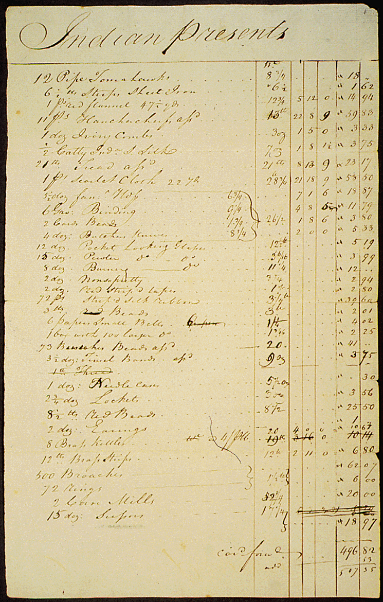
- Discovering Lewis and Clark: List of Provisions with Text Overlay
- Thomas Jefferson Foundation: Expedition Packing List
Documents
View some of the letters and journal entries from the journey; for example:
- Library of Congress: Meriwether Lewis to Thomas Jefferson
- Library of Congress: William Clark to Thomas Jefferson
- Library of Congress: William Clark to Meriwether Lewis
Jefferson's Secret Message to Congress Regarding the Lewis and Clark Expedition:
- National Archives: Jefferson's Secret Message to Congress (shown below)
- National Archives: Transcript of Jefferson's Secret Message to Congress
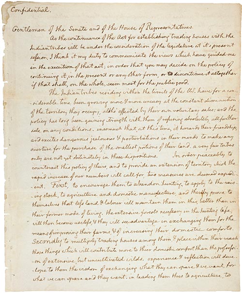
- National Archives: Jefferson Looks Westward
- National Archives: Lewis & Clark Expedition
- Journals of the Lewis & Clark Expedition: Images & Maps
- Lewis & Clark’s Historic Trail: Journal Transcripts
Part 1 Assignment: Document Analysis and Written Essay
- Download the “Analyze a Written Document” template.
- Use the template to analyze one of the written documents at the links above; or, use the links on this page to search for a written primary source document related to the Louisiana Purchase or the Lewis and Clark Corps of Discovery expedition.
- Write a 1.5 – 2 page summary of your analysis of your chosen document. Be sure to include a link to the primary source document you chose to analyze.
- Submit your completed “Analyze a Written Document” sheet and your written summary to your Google Folder and notify your instructor when your work is ready for grading.
Learning Activities Part 2: Mapping Technology
Google Earth Voyager
Use Google Earth Voyager to view the path of the Corps of Discovery expedition from St. Charles, Missouri to the Pacific Ocean. Read the descriptions and watch the videos for pages 1-12.
Maps
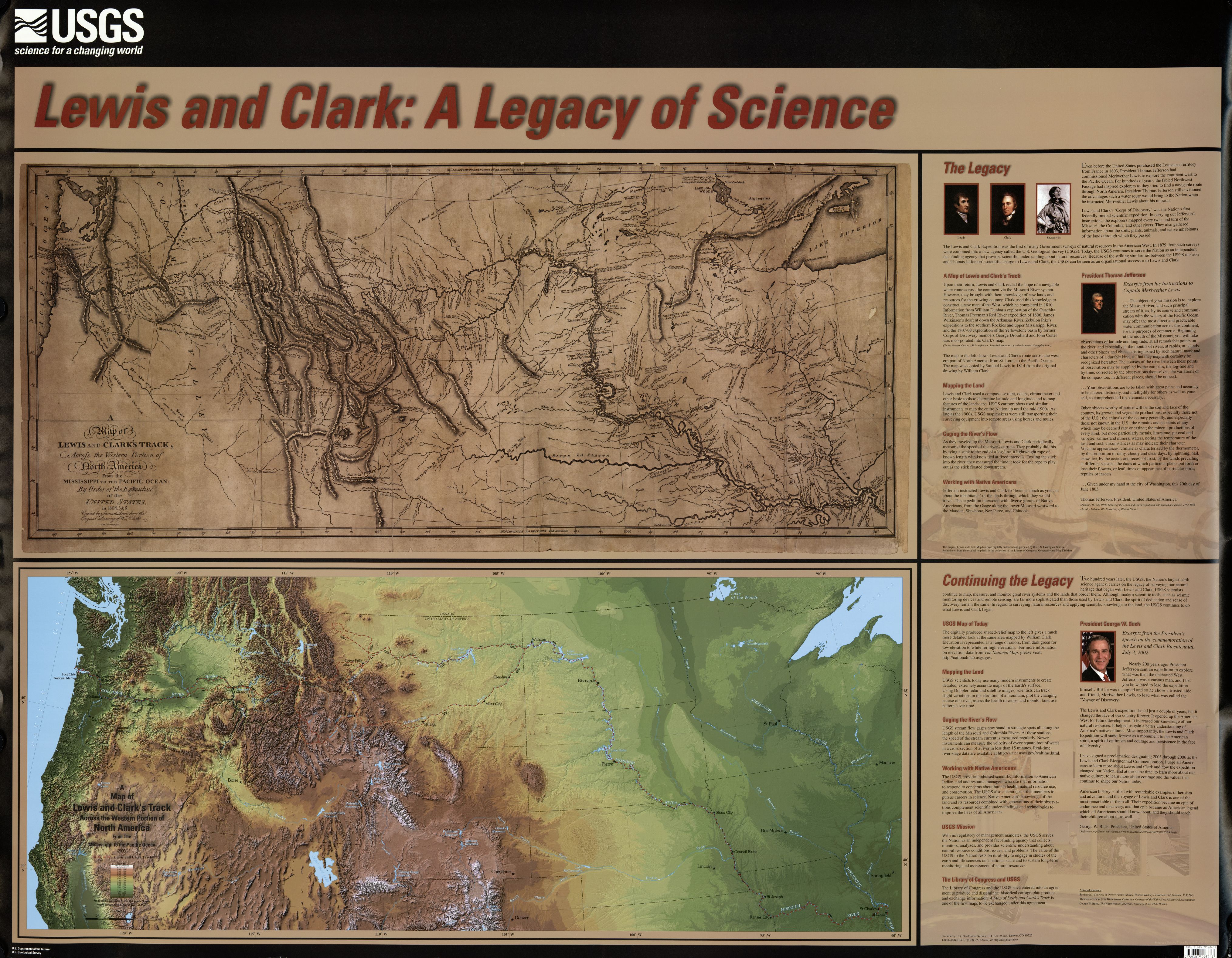
Various maps have been drawn of the western region of the United States during that era, including the map below (top), comparing the journey of Lewis and Clark to a United States Geologic Survey map (bottom) of the same area:
View other maps of the region:
- University of Washington: The Louisiana Purchase
- Library of Congress: Lewis & Clark and the Revealing of America
- Library of Congress: Discovering the Legacy of Lewis and Clark
- David Rumsey Map Collection: Map showing route of the Lewis & Clark Expedition
- Public Broadcasting Service: Interactive Trail Map
- Lewis & Clark Trail Heritage Foundation: Travel the L&C Trail
- Journals of the Lewis & Clark Expedition: Images & Maps
- Lewis and Clark Across Missouri: Campsites
View animations of the expedition’s virtual river travel:
Part 2 Written Discussion: Map Overlays
- Read the MIT Technology Review article: From Lewis and Clark to Landsat
- View the Lewis and Clark composite map mentioned in the article.
- View the original Lewis and Clark map.
View a Georeferencer overlay that includes the composite map described in the article:
- Observe the points in the red dots that have been mapped to align to both versions of the map. (Note: The points in the red dots do not necessarily correspond to the Lewis and Clark journey, nor are they all located within the United States; they are merely coordinates to align the base and overlay maps together. The Lewis and Clark Corps of Discovery route is shown in the rough sketchlike lines from St. Louis, MO to the Oregon coastline.)
- Click the Overlay link in the menu at the top (to switch from Side by Side view to Overlay view) and show the map placed over the modern MapTiler© version. Note again the points in red that have been mapped to align to both versions, and the distorted shape of the overlay.
- Use the slider in the upper right to view the base MapTiler© map, then the overlay.
- Use the + and – links on the left to zoom in and out, as needed, so you can compare the details between the base map and the overlay map.
Participate in this Module’s written Discussion Board, writing answers to the following questions:
- Why do you think there are so many differently contoured and shaped maps of this region?
- What are some causes for maps appearing different?
- Does the overlay map in the Lewis and Clark composite map exactly match the base MapTiler© map below it? If not, how does it differ?
- Why does the overlay map stretch and bend? Why isn't it a rectangle, as it appears in the Side by Side view?
- Why do you think some of the landmarks on a map, such as lakes and rivers, might appear different today than they used to?
- Can you think of reasons why rivers might not take the exact same path today as they have in the past?
- Once you have made your initial post answering the questions above, review your peers’ posts, and respond to at least two of your peers, discussing in writing whether you agreed with their observations, or whether they differed from yours, and in what ways.
Resources
- Google Earth Voyager. (2018). Explorers: Lewis and Clark. Retrieved from https://tinyurl.com/yc3pcah4
- Lewis, S., Clark, W., Harrison, S. & Geological Survey, U. S. (2003). Lewis and Clark, a Legacy of Science. U.S. Dept. of the Interior, U.S. Geological Survey. Retrieved from https://www.loc.gov/item/2003621336/
- National Archives and Records Administration. Jefferson's Secret Message to Congress Regarding the Lewis & Clark Expedition (1803). Retrieved from https://www.ourdocuments.gov/doc.php?flash=true&doc=17
- National Archives and Records Administration. (1998). List of Indian presents purchased by Meriwether Lewis in preparation for the expedition to the West. Retrieved from https://www.ourdocuments.gov/doc.php?flash=true&doc=17
- National Park Service. (2018). Lewis and Clark Expedition. Retrieved from https://www.nps.gov/nr/travel/lewisandclark/index.htm
- Public Broadcasting Service. (2018). Lewis & Clark: The Journey of the Corps of Discovery. Retrieved from http://www.pbs.org/lewisandclark/inside/index.html